
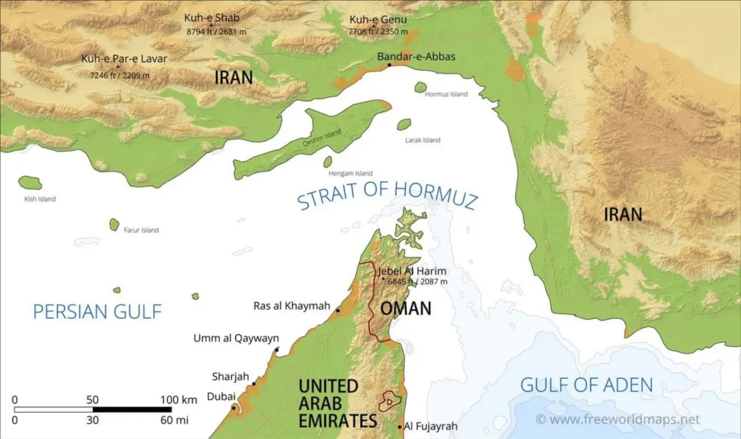
It’s common knowledge that the now much talked about Strait of Hormuz is only 21 miles wide at it’s narrowest point. I learned this fact in grade school in the 1960s in geography lessons. Even MAGAs know it. It’s been a ‘choke point’ for shipping/trade since long before any of us were born. However there’s theory and reality and in practical terms when it comes to large crude oil carriers and large cargo ships only six miles of those “21 miles” have to be blocked (or a credible threat to do so) to shut down a huge chunk of international trade. It gets worse.
Most of you know that countries can claim up to twelve miles out from their shoreline as “their” waters under their control and laws. Once outside that limit a boat or ship is in International Waters and International Law takes over. Two time twelve equals 24 miles and there’s only 21 miles between Iran on the north side and Oman on the south. BOTH have formally declared the twelve miles from their shores as their territorial waters. See the problem? In theory the Strait is open to international shipping. There’s even a maritime law saying so.
However on both sides of the Strait you have countries that claim a right to control one side or the other – with three overlapping miles. Yet there’s an international law that says regardless of that ships have a right to pass back and forth through the Strait. So who controls or doesn’t control what? The answer is… It’s complicated. For some clarity you can read some of the details in a March 2026 article from the outlet ontime+. It gives a fairly straightforward explanation of who controls what waters and just as importantly covers the issue of the actual shipping lanes I mentioned:
The Strait of Hormuz narrows to about 21 miles (≈33 km) at its tightest point, but the navigable shipping lanes are far narrower. • The internationally recognised Traffic Separation Scheme (TSS) uses two 2-mile-wide lanes (inbound and outbound) separated by a 2-mile buffer zone. • Because both Iran and Oman claim a 12-nautical-mile territorial sea, most of the strait’s water at the chokepoint sits inside state territorial waters, while international law still treats it as a strait used for international navigation where transit passage should not be impeded.
Ah, but here’s where not well known but pesky details come into play. And those details are startling to many people. That’s certainly been my experience over the years (and I’m an old fart) when things have flared up with Iran and them ‘closing the Strait’ has come up in discussion when things have flared up in the middle east. Let’s start with the basics, by which I mean for shipping the Strait is nowhere near 21 miles wide:
- At the narrowest point, Hormuz is around 21 miles wide, but that headline number is misleading for operational risk. The “usable corridor” for deep-draft commercial traffic is constrained by routing discipline (collision avoidance), navigation limits, and security posture.
- The practical backbone is the TSS:
- Inbound lane: ~2 miles wide
- Outbound lane: ~2 miles wide
- Separation (buffer) zone: ~2 miles wide
- This produces a narrow, predictable conveyor belt — exactly what raises sensitivity to mining, harassment, or even a short-term disruption.
I should note there’s a good reason for that ‘buffer zone’ between the two heavy ship shipping lanes. The seas are rougher there than people realize. Strong currents, periods of low visibility, dealing with small boats trying to zip around like some a-hole motorcyclist weaving through traffic on land roads etc. Also, contrary to what most people think you can’t make a quick course change in ships of this size. It takes a lot more than a few boat lengths and quite a few minutes. Even at reduced speeds in this narrow zone the distance to slow down and/or stop is measured in miles. Again, not three or four boat lengths.
As a result not only would a country, Iran for instance need to put a 21 mile wide barrier of mines in place, or even six miles. Ships try to stay in the middle of both the ingoing two mile wide and outgoing two mile wide channel. It doesn’t take any small ships Iran might have kept hidden away to head out and lay a few mines. Dudes in rubber boats could tow a handful of submerged mines at night on in foggy conditions. Thanks to hand-held GPS devices they could be place exactly where they would need to be.
So now you’re thinking about that international law that says regardless of what countries on either side of the Strait say the corridor has to remain open to ships going back and forth no matter what country’s flag they fly. Including military vessels. So, you ask, what’s the problem? Again, it’s complicated. Why is covered in the linked article:
Both littoral states have codified 12-nautical-mile territorial seas:
• Iran: its 1993 marine areas act specifies a 12-nm territorial sea measured from baselines.
• Oman: U.S. State Department’s Limits in the Seas (LIS) on Oman notes the territorial sea extends 12 nm.
When a strait is around 21 nm wide at its narrowest, two 12-nm territorial seas effectively “close” the gap: ships transiting the strait pass through Iranian and Omani territorial waters, not high seas, even though the route is used for international navigation.
Another quick primer. The United Nations Convention on the Law of the Sea (known as UNCLOS) in effect has been active since 1994. It’s the comprehensive international “constitution for the oceans” regulating maritime space, resources, and environmental protection. It also establishes key maritime zones like the 12-nautical mile territorial sea and 200-mile Exclusive Economic Zone (EEZ). It’s been ratified by 169 parties/countries. Which brings me to this from the lined article:
Under UNCLOS Part III (straits used for international navigation), states bordering straits shall not hamper transit passage and must publicise dangers to navigation.
Complication: Iran has signed but not ratified UNCLOS and has historically argued for a narrower navigation regime than full transit passage in Hormuz, which is why legal debate resurfaces whenever tensions rise.
Operationally, however, shipping insurers, flag states, and navies tend to behave as if the strait functions under the international-strait logic — because global commerce cannot price a chokepoint as “optional.”
That gets us to the heart of the matter. Iran is a signatory (as are we) to UNCLOS but (surprise, surprise) they never ratified it. For the record, neither have WE. So they say they don’t have to follow it even though there’s no small amount of irony they are using the provisions of the agreement to enforce provisions regarding territorial waters and economic zones! It remind me of the asshats here who claim they are ‘Sovereign Citizens’ and not subject to any local, state or federal laws. While at the same time they use publicly funded roads and utilities, U.S. currency etc.
I don’t know how long it would take for a case to be heard in whatever International Court has jurisdiction but I’m pretty sure that like federal judges in the U.S. they think they are oh so special and won’t let ANYONE pressure them to act until they goddam well feel like doing so. Meanwhile every day the Strait is close real economic harm is taking place around the world. So it’s a mess and since Trump has declared the freaking UNITED STATES is going to shut down ALL traffic (in both directions) through the Strait sometime on Monday the 13th said mess is going to get worse.
I just wanted you all to know that narrow as the Strait seems it’s actually much narrower than what you thought. As such it will be a helluva lot easier for Iran to mine it and if we or any countries with minesweeper capability try to clear those narrow shipping lanes a single asshole with a shoulder fired missile lacking discipline might just, orders be damned shoot one off. It’s going to be a long, long week.
Friends, I know everyone begs you for money. I promise, among all those asking for spare change, we are the smallest and the hardest working. We’re a group of old, disabled people, except for one writer in his mid-50s. The rest of us are in our sixties and seventies, and this is a labor of love. All we’re asking for is the chance to keep telling the truth about Trump and help ensure democracy survives. If you can help, please do. Thank you. Ursula



















Thank you SO MUCH for this information. It really shows a lot about how the Strait works, and you made it understandable. I appreciate you taking the time to do so.